By studying rocks, minerals and landscapes, geoscientists uncover information about the Earth’s evolution, shaping the world we see today. Although this backwards-looking approach has many uses, it doesn’t always address modern challenges in a world shaped by human activity. Here, we discuss geoscientific advances that can help us forecast and mitigate against natural disasters, produce clean energy, and combat the effects of climate change.
01
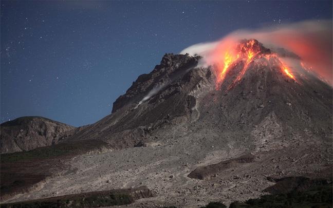
AI, with its growing presence in science and technology, offers significant potential. For example, machine learning algorithms can process large quantities of earth observation data, such as satellite images and Interferometric Synthetic Aperture Radar (InSAR). As discussed in a previous Insight, these technologies can detect and classify natural processes and predict behaviours, such as determining whether volcanic deformation may result in eruption, or whether strain on a fault may increase the likelihood of large magnitude earthquakes. As AI evolves and computing power increases, so too will its importance and applications.
Studies of the practical applications of machine learning for volcano monitoring[1] highlight that although challenges still exist (e.g. data availability, calibration and tailoring of processing algorithms ), these methods show promise and are continuously improving. Machine learning for earthquakes mostly centres around predicting magnitude, trends and occurrence [2] based on past events. Organisations like Temblor Inc. also use machine learning methods to develop stochastic models for use by insurers and other risk managers[3]. However, the increasing energy demands and environmental impacts of AI infrastructure must be considered, in order to avoid exacerbating the climate crisis.
02
Remote earth observation through satellite imagery is an established but continuously improving field. New satellite missions, like ESA’s Sentinel-1 and Harmony are regularly launched in collaboration with universities and organisations such as the Centre for Observation and Modelling of Earthquakes, Volcanoes and Tectonics (COMET). These missions provide greater spatial and temporal coverage of the Earth, and more comprehensive imaging of hazards such as volcano deformation [4], volcanic gas emissions[5], earthquake displacement, landslide movement [6] and surface deformation from groundwater extraction[7][8]. Ground deformation also helps monitor risks from fluid injection into the subsurface, as is the case for geothermal energy generation, and subsidence from mining activities [9]. Much of the work being done in these fields was presented at the recent COMET Science Meeting, with the WTW Research Network (WRN) serving as an associate member with current and prospective collaborative projects on geohazard topics including landslide, tsunami and secondary hazard modelling.
A potential revolution in geohazard monitoring, reducing reliance on expensive instrumentation in hard-to-reach areas, is using fibre optic cables for monitoring seismicity through Distributed Acoustic Sensing (DAS )[10]. This repurposing of existing global fibre optic networks including across the sea floor, offers faster and more accurate data collection than some onshore instruments, enhancing monitoring networks and early warnings for risks such as fault ruptures, volcanic flank collapses, and marine landslides.
03
Advancements in renewable energy are another area where geoscience research plays a key role, both on land and at sea. Beyond traditional geothermal energy, which uses active volcanic systems like those in Iceland [11] and igneous rocks such as those in Cornwall and Scotland, low-temperature geothermal solutions are being explored including sedimentary basins [12] [13] and decommissioned mines[14], broadening the scope of where geothermal heat can be harnessed. However, this form of energy generation requires pumping water into the subsurface, which like hydraulic fracturing can cause geohazards like microseismicity and subsidence which requires careful monitoring by asset managers and risk engineers. The wider geological and hydrological hazards of mine water heating are discussed further within WTW’s 2024 Mining Risk Review.
Renewable energy from offshore wind, solar and tidal sources will become increasingly vulnerable to geological hazards as new infrastructure is constructed. Earthquakes, seafloor or coastal landslides, and submarine and island explosive volcanism can trigger tsunamis, threatening wind farms, submarine cables, nuclear facilities, and maritime industries.
Events like the ~6100BC Storegga slide in the North Atlantic[15], the 2004 Indian Ocean earthquake and tsunami [16], and the 2022 Hunga-Tonga eruption in the South Pacific [17] demonstrate the risk from these hazards, which will likely increase with rising sea levels, increasing global trade and offshore energy expansion.
04
Finally, another technology that may help combat the climate crisis, though currently viewed with extreme caution, is geoengineering. This includes techniques such as seeding the oceans with iron or volcanic rocks containing olivine to absorb more carbon dioxide, or spraying water from the oceans into low-level clouds to reflect some of the sun’s radiation. The chief of the National Oceanic and Atmospheric Administration (NOAA) has said that geoengineering is likely to be needed, at least in part, to address increasing wildfires and extreme weather in the U.S. However, NOAA scientists have also warned that geoengineering should be more thoroughly studied to understand these techniques' impact on ecosystems [18].
In areas like hazard monitoring, modelling, and risk assessments for renewable energy infrastructure, the WRN actively champions the latest science from academia and industry. By partnering with universities, organisations like the Global Earthquake Model Foundation, Global Volcanic Risk Alliance and Mitiga Solutions, as well as membership of COMET and attendance of conferences such as the European Geosciences Union (EGU), we are learning new methods for monitoring geohazards, modelling potential risks and secondary effects, and helping devise solutions to improve resilience.